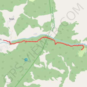
Kheer ganga trek.gpx
- Distance: 12.3 Km
- Elevation gain: 1,248 m
- Maximum elevation: 2,817 m
- Elevation loss: 655 m
- Minimum elevation: 2,197 m
- Moving time: 4 h 42 m
- Moving speed: 2.6 Km/h
- Maximum speed: 15.9 Km/h
- Total time: 6 h 53 m
- Global speed: 1.8 Km/h
Interactive trail map
Trail profile
- Distance: 12.3 Km
- Elevation gain: 1,248 m
- Maximum elevation: 2,817 m
- Elevation loss: 655 m
- Minimum elevation: 2,197 m
- Moving time: 4 h 42 m
- Moving speed: 2.6 Km/h
- Maximum speed: 15.9 Km/h
- Total time: 6 h 53 m
- Global speed: 1.8 Km/h
About this trail
Name: Kheer ganga trek.gpx trail, distance, elevation, map, profile, GPS track
Start: Tulga, Barsheni, Bhuntar, Kullu, Himachal Pradesh, India (32.00045 77.44534)
Coordinates: 31.99382 77.44534 32.00255 77.50822