Mount Monadnock and Monte Rosa loop via Smith Trail
- Distance: 8.4 Km
- Elevation gain: 517 m
- Maximum elevation: 950 m
- Elevation loss: 518 m
- Minimum elevation: 459 m
- Moving time: 2 h 58 m
- Moving speed: 2.8 Km/h
- Maximum speed: 9.8 Km/h
- Total time: 3 h 53 m
- Global speed: 2.2 Km/h
Interactive trail map
Trail profile
- Distance: 8.4 Km
- Elevation gain: 517 m
- Maximum elevation: 950 m
- Elevation loss: 518 m
- Minimum elevation: 459 m
- Moving time: 2 h 58 m
- Moving speed: 2.8 Km/h
- Maximum speed: 9.8 Km/h
- Total time: 3 h 53 m
- Global speed: 2.2 Km/h
About this trail
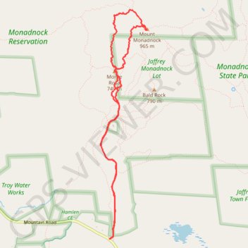
Name: Mount Monadnock and Monte Rosa loop via Smith Trail trail, distance, elevation, map, profile, GPS track
Coordinates: 42.83524 -72.11598 42.86388 -72.10810
Other hiking, mountain biking, running and outdoor activity trails
Click on a trail to view its statistics, map and profile.
Bald Rock, Paradise Valley trail and others in the Monadnock State Park
United States > New Hampshire > Cheshire County > Jaffrey
Distance: 7.5 Km • Elevation gain: 550 m • Maximum elevation: 890 m
Lost Paradise Valley Loop Trail
United States > New Hampshire > Cheshire County > Jaffrey
Distance: 7.7 Km • Elevation gain: 550 m • Maximum elevation: 890 m
Lost Smith Trail
United States > New Hampshire > Cheshire County > Jaffrey
Distance: 8.5 Km • Elevation gain: 506 m • Maximum elevation: 950 m