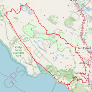
Point Reyes Loop
- Distance: 100.3 Km
- Elevation gain: 1,900 m
- Maximum elevation: 236 m
- Elevation loss: 1,894 m
- Minimum elevation: 0 m
- Moving time: 6 h 32 m
- Moving speed: 15.3 Km/h
- Maximum speed: 39.7 Km/h
- Total time: 6 h 32 m
- Global speed: 15.3 Km/h
Interactive trail map
Trail profile
- Distance: 100.3 Km
- Elevation gain: 1,900 m
- Maximum elevation: 236 m
- Elevation loss: 1,894 m
- Minimum elevation: 0 m
- Moving time: 6 h 32 m
- Moving speed: 15.3 Km/h
- Maximum speed: 39.7 Km/h
- Total time: 6 h 32 m
- Global speed: 15.3 Km/h
About this trail
Name: Point Reyes Loop trail, distance, elevation, map, profile, GPS track
Coordinates: 37.86288 -122.80631 38.09731 -122.52322
Other hiking, mountain biking, running and outdoor activity trails
Click on a trail to view its statistics, map and profile.
Arch Rock Loop via Glen Trail, Coast Trail and Bear Valley Trail
United States > California > Marin County
Starting from Glen Campground, this loop leaves the quiet backcountry camp area on the Glen Trail, crossing wooded ridges, small drainages, coastal scrub and open grassy slopes before bending westward toward the exposed Pacific side of Point Reyes National Seashore. The route then follows the Coast Trail…
Distance: 9.6 Km • Elevation gain: 347 m • Maximum elevation: 245 m
Canopy, Lost and Fern Creek Trails Loop in Muir Woods National Monument
United States > California > Marin County
The Canopy, Lost, and Fern Creek Trails Loop in Muir Woods National Monument offers hikers a serene journey through towering redwoods, lush fern-lined paths, and tranquil creek crossings. The trail ascends gently, providing elevated views of the forest canopy, and descends alongside the picturesque Fern Creek,…
Distance: 4.9 Km • Elevation gain: 262 m • Maximum elevation: 224 m
Alamere Falls via Coast Trail in Point Reyes National Seashore
United States > California > Marin County
The hike to Alamere Falls via the Coast Trail in Point Reyes National Seashore offers a diverse array of landscapes, including coastal bluffs, serene lakes, and lush forests. Along the way, hikers can enjoy panoramic ocean vistas, pass by tranquil bodies of water such as Bass Lake and Pelican Lake, and…
Distance: 13.1 Km • Elevation gain: 475 m • Maximum elevation: 186 m
Old Mine, Dipsea and Steep Ravine Trails Loop in Mount Tamalpais State Park
United States > California > Marin County
The Old Mine, Dipsea, and Steep Ravine Trails Loop in Mount Tamalpais State Park offers hikers a diverse experience, featuring towering redwood forests, cascading waterfalls, and panoramic views of the Pacific Ocean. Along the route, one can traverse lush fern-lined paths, navigate wooden ladders beside Webb…
Distance: 6.2 Km • Elevation gain: 310 m • Maximum elevation: 459 m
Cataract Falls Trail from Alpine Lake in Mount Tamalpais Watershed
United States > California > Marin County
The Cataract Trail in Mount Tamalpais Watershed offers hikers a serene journey through dense forests, accompanied by the soothing sounds of cascading waterfalls. Along the path, one can observe a series of waterfalls, including Cataract Falls, Helen Markt Falls, Midway Falls, and Laurel Dell Falls, each…
Distance: 4.9 Km • Elevation gain: 370 m • Maximum elevation: 537 m
Dipsea Trail, Steep Ravine Trail and Matt Davis Trail Loop in Mount Tamalpais State Park
United States > California > Marin County > Stinson Beach
The Dipsea Trail, Steep Ravine Trail, and Matt Davis Trail Loop in Mount Tamalpais State Park offers hikers a diverse experience, beginning at Stinson Beach and ascending through coastal hills with expansive ocean vistas. The route transitions into a dense redwood forest alongside Webb Creek, featuring…
Distance: 11.9 Km • Elevation gain: 702 m • Maximum elevation: 496 m
Alamere Falls via Coast Trail in Phillip Burton Wilderness Area
United States > California > Marin County
The Alamere Falls hike along the Coast Trail in the Point Reyes National Seashore is a enchanting journey that offers a variety of landscapes, from coastal views to serene lakes. Hikers are treated to a mix of coastal cliffs, rolling hills, and lush forests, with the opportunity to see two tranquil lakes along…
Distance: 6.5 Km • Elevation gain: 215 m • Maximum elevation: 186 m
Muir Woods Bootjack Trail Loop
United States > California > Marin County
Loop hike via Fern Creek Trail, Bootjack Trail, TCC Trail, Stapleveldt Trail, Ben Johnson Trail and Hillside Trail in the Muir Woods National Monument and Mount Tamalpais State Park. #Hiking #Loop #Forest #River #Nature #Mountain #Park
Distance: 9.5 Km • Elevation gain: 506 m • Maximum elevation: 410 m
Muir Woods Canopy Trail Loop
United States > California > Marin County
Loop hike through Muir Woods National Monument via Canopy Trail and Fern Creek Trail along the Fern Creek and the Redwook Creek via the Redwood Tree Slice, the Pinchot Tree and the Cathedral Grove. #Hiking #Loop #Forest #Nature #Mountain #River
Distance: 4.7 Km • Elevation gain: 247 m • Maximum elevation: 220 m
Point Reyes National Seashore
United States > California > Marin County > Blakes Landing
Point Reyes, Route 1 to Lighthouse
Distance: 51.9 Km • Elevation gain: 821 m • Maximum elevation: 154 m
Walking paths in and around Lucas Valley Park in Lucas Valley
United States > California > Marin County > Lucas Valley
Distance: 1.3 Km • Elevation gain: 4 m • Maximum elevation: 46 m
Hike near Lucas Valley
United States > California > Marin County > San Rafael > Lucas Valley-Marinwood
Distance: 5.3 Km • Elevation gain: 210 m • Maximum elevation: 177 m
Hike near Nicasio Reservoir
United States > California > Marin County
Distance: 1.7 Km • Elevation gain: 30 m • Maximum elevation: 77 m