Squirrel Hills
Evening MTB Ride
- Distance: 15.4 Km
- Elevation gain: 279 m
- Maximum elevation: 586 m
- Elevation loss: 279 m
- Minimum elevation: 511 m
- Moving time: 1 h 22 m
- Moving speed: 11.2 Km/h
- Maximum speed: 34.8 Km/h
- Total time: 1 h 55 m
- Global speed: 8.0 Km/h
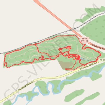
Interactive trail map
Trail profile
- Distance: 15.4 Km
- Elevation gain: 279 m
- Maximum elevation: 586 m
- Elevation loss: 279 m
- Minimum elevation: 511 m
- Moving time: 1 h 22 m
- Moving speed: 11.2 Km/h
- Maximum speed: 34.8 Km/h
- Total time: 1 h 55 m
- Global speed: 8.0 Km/h
About this trail
Name: Squirrel Hills trail, distance, elevation, map, profile, GPS track
Start: Perimiter Trail, Rural Municipality of Minto - Odanah, Manitoba, Canada (50.25554 -99.88713)
End: Perimiter Trail, Rural Municipality of Minto - Odanah, Manitoba, Canada (50.25555 -99.88722)
Coordinates: 50.25407 -99.90718 50.25892 -99.88612
Other hiking, mountain biking, running and outdoor activity trails
Click on a trail to view its statistics, map and profile.
Squirrel Hills
Canada > Rural Municipality of Minto - Odanah
Evening Ride
Distance: 16.2 Km • Elevation gain: 303 m • Maximum elevation: 586 m