Thank you for supporting this site ❤️
Make a donation
Make a donation
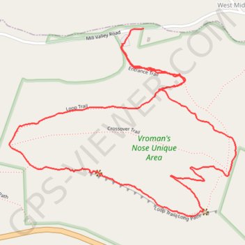
Vroman's Nose Loop Trail
- Distance: 3.1 Km
- Elevation gain: 144 m
- Maximum elevation: 353 m
- Elevation loss: 147 m
- Minimum elevation: 231 m
- Moving time: 52 m 24 s
- Moving speed: 3.6 Km/h
- Maximum speed: 17.2 Km/h
- Total time: 59 m 59 s
- Global speed: 3.1 Km/h
Interactive trail map
Thank you for supporting this site ❤️
Make a donation
Make a donation
Trail profile
- Distance: 3.1 Km
- Elevation gain: 144 m
- Maximum elevation: 353 m
- Elevation loss: 147 m
- Minimum elevation: 231 m
- Moving time: 52 m 24 s
- Moving speed: 3.6 Km/h
- Maximum speed: 17.2 Km/h
- Total time: 59 m 59 s
- Global speed: 3.1 Km/h
Thank you for supporting this site ❤️
Make a donation
Make a donation
About this trail
Name: Vroman's Nose Loop Trail trail, distance, elevation, map, profile, GPS track
Start: Entrance Trail, Town of Fulton, Schoharie County, New York, United States (42.59445 -74.35813)
Coordinates: 42.58936 -74.36268 42.59492 -74.35355
Thank you for supporting this site ❤️
Make a donation
Make a donation