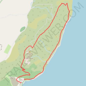
Mount John Walkway loop via Mount John Observatory above Tekapo Lake
- Distance: 8.2 Km
- Elevation gain: 379 m
- Maximum elevation: 1,007 m
- Elevation loss: 369 m
- Minimum elevation: 717 m
- Moving time: 2 h 4 m
- Moving speed: 3.9 Km/h
- Maximum speed: 5.6 Km/h
- Total time: 2 h 26 m
- Global speed: 3.3 Km/h
Interactive trail map
Trail profile
- Distance: 8.2 Km
- Elevation gain: 379 m
- Maximum elevation: 1,007 m
- Elevation loss: 369 m
- Minimum elevation: 717 m
- Moving time: 2 h 4 m
- Moving speed: 3.9 Km/h
- Maximum speed: 5.6 Km/h
- Total time: 2 h 26 m
- Global speed: 3.3 Km/h
About this trail
Name: Mount John Walkway loop via Mount John Observatory above Tekapo Lake trail, distance, elevation, map, profile, GPS track
Coordinates: -43.99563 170.45921 -43.97032 170.48266
Other hiking, mountain biking, running and outdoor activity trails
Click on a trail to view its statistics, map and profile.
Lake Tekapo - Lake Pukaki - Glenntanner
New Zealand > Canterbury > Mackenzie District > Lake Tekapo
#Bike
Distance: 79.8 Km • Elevation gain: 605 m • Maximum elevation: 751 m