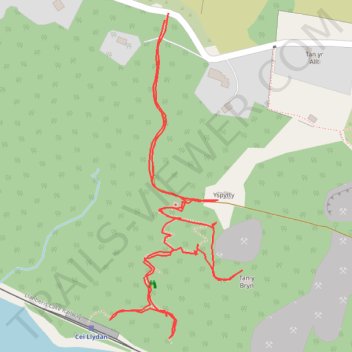
Bluebell walk at Menter Fachwen
Walk to look at the Bluebells at Menter Fachwen and found a new permissive path
- Distance: 1.7 Km
- Elevation gain: 112 m
- Maximum elevation: 208 m
- Elevation loss: 114 m
- Minimum elevation: 106 m
- Moving time: 43 m 46 s
- Moving speed: 2.3 Km/h
- Maximum speed: 4.1 Km/h
- Total time: 1 h 10 m
- Global speed: 1.4 Km/h
Interactive trail map
Trail profile
- Distance: 1.7 Km
- Elevation gain: 112 m
- Maximum elevation: 208 m
- Elevation loss: 114 m
- Minimum elevation: 106 m
- Moving time: 43 m 46 s
- Moving speed: 2.3 Km/h
- Maximum speed: 4.1 Km/h
- Total time: 1 h 10 m
- Global speed: 1.4 Km/h
About this trail
Name: Bluebell walk at Menter Fachwen trail, distance, elevation, map, profile, GPS track
Start: Fachwen, Llanddeiniolen, Brynrefail, Gwynedd, Wales, LL55 3HD, United Kingdom (53.13423 -4.13067)
End: Fachwen, Llanddeiniolen, Brynrefail, Gwynedd, Wales, LL55 3HD, United Kingdom (53.13415 -4.13074)
Coordinates: 53.13061 -4.13176 53.13423 -4.12930
Other hiking, mountain biking, running and outdoor activity trails
Click on a trail to view its statistics, map and profile.
Ultra-Trail Snowdonia Eryri UTS 100M
United Kingdom > Wales > Gwynedd > Llanberis
Distance: 163.3 Km • Elevation gain: 9,704 m • Maximum elevation: 1,058 m