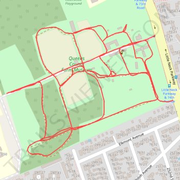
Queens County Farm Museum
- Distance: 3.8 Km
- Elevation gain: 16 m
- Maximum elevation: 41 m
- Elevation loss: 17 m
- Minimum elevation: 33 m
- Moving time: 18 m 56 s
- Moving speed: 12.0 Km/h
- Maximum speed: 25.8 Km/h
- Total time: 18 m 56 s
- Global speed: 12.0 Km/h
Interactive trail map
Trail profile
- Distance: 3.8 Km
- Elevation gain: 16 m
- Maximum elevation: 41 m
- Elevation loss: 17 m
- Minimum elevation: 33 m
- Moving time: 18 m 56 s
- Moving speed: 12.0 Km/h
- Maximum speed: 25.8 Km/h
- Total time: 18 m 56 s
- Global speed: 12.0 Km/h
About this trail
Name: Queens County Farm Museum trail, distance, elevation, map, profile, GPS track
Start: Little Neck Parkway, Queens, Queens County, New York, 11001, United States (40.74846 -73.71963)
Coordinates: 40.74541 -73.72458 40.74874 -73.71902
Other hiking, mountain biking, running and outdoor activity trails
Click on a trail to view its statistics, map and profile.