Thank you for supporting this site ❤️
Make a donation
Make a donation
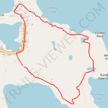
Oliver's Cove Loop Trail
- Distance: 3.5 Km
- Elevation gain: 28 m
- Maximum elevation: 7 m
- Elevation loss: 28 m
- Minimum elevation: -1 m
- Moving time: 1 h 3 m
- Moving speed: 3.3 Km/h
- Maximum speed: 6.6 Km/h
- Total time: 1 h 14 m
- Global speed: 2.8 Km/h
Interactive trail map
Thank you for supporting this site ❤️
Make a donation
Make a donation
Trail profile
- Distance: 3.5 Km
- Elevation gain: 28 m
- Maximum elevation: 7 m
- Elevation loss: 28 m
- Minimum elevation: -1 m
- Moving time: 1 h 3 m
- Moving speed: 3.3 Km/h
- Maximum speed: 6.6 Km/h
- Total time: 1 h 14 m
- Global speed: 2.8 Km/h
Thank you for supporting this site ❤️
Make a donation
Make a donation
About this trail
Name: Oliver's Cove Loop Trail trail, distance, elevation, map, profile, GPS track
Start: Oliver's Cove Trail, Tilting, Newfoundland, Newfoundland and Labrador, Canada (49.70016 -54.05734)
Coordinates: 49.69649 -54.05885 49.70635 -54.04668
Thank you for supporting this site ❤️
Make a donation
Make a donation