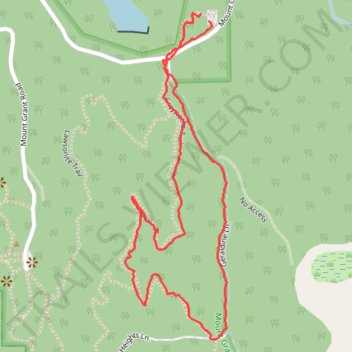
Greywacke Trail, Subduction Loop and Geraldine Lane loop walk in Mount Grant Preserve
- Distance: 2.0 Km
- Elevation gain: 51 m
- Maximum elevation: 149 m
- Elevation loss: 52 m
- Minimum elevation: 108 m
- Moving time: 39 m 19 s
- Moving speed: 3.0 Km/h
- Maximum speed: 6.1 Km/h
- Total time: 48 m 50 s
- Global speed: 2.4 Km/h
Interactive trail map
Trail profile
- Distance: 2.0 Km
- Elevation gain: 51 m
- Maximum elevation: 149 m
- Elevation loss: 52 m
- Minimum elevation: 108 m
- Moving time: 39 m 19 s
- Moving speed: 3.0 Km/h
- Maximum speed: 6.1 Km/h
- Total time: 48 m 50 s
- Global speed: 2.4 Km/h
About this trail
Name: Greywacke Trail, Subduction Loop and Geraldine Lane loop walk in Mount Grant Preserve trail, distance, elevation, map, profile, GPS track
Start: Mount Grant Road, San Juan County, Washington, United States (48.54462 -123.12182)
End: Mount Grant Road, San Juan County, Washington, United States (48.54451 -123.12163)
Coordinates: 48.53902 -123.12381 48.54465 -123.12116
Other hiking, mountain biking, running and outdoor activity trails
Click on a trail to view its statistics, map and profile.
Mount Grant via Lawsonite Trail and Graywacke Trail
United States > Washington > San Juan County
Distance: 3.8 Km • Elevation gain: 136 m • Maximum elevation: 222 m
Lawsonite Trail and Greenwake Trail Loop below Mount Grant
United States > Washington > San Juan County
Distance: 2.9 Km • Elevation gain: 111 m • Maximum elevation: 211 m
Geraldine Lane in Mount Grant Preserve
United States > Washington > San Juan County
Distance: 2.0 Km • Elevation gain: 29 m • Maximum elevation: 123 m