Thank you for supporting this site ❤️
Make a donation
Make a donation
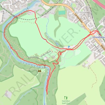
Loop Walk in Chatelherault Park
- Distance: 5.0 Km
- Elevation gain: 70 m
- Maximum elevation: 84 m
- Elevation loss: 72 m
- Minimum elevation: 36 m
- Moving time: 56 m 2 s
- Moving speed: 5.3 Km/h
- Maximum speed: 14.0 Km/h
- Total time: 58 m 12 s
- Global speed: 5.1 Km/h
Interactive trail map
Thank you for supporting this site ❤️
Make a donation
Make a donation
Trail profile
- Distance: 5.0 Km
- Elevation gain: 70 m
- Maximum elevation: 84 m
- Elevation loss: 72 m
- Minimum elevation: 36 m
- Moving time: 56 m 2 s
- Moving speed: 5.3 Km/h
- Maximum speed: 14.0 Km/h
- Total time: 58 m 12 s
- Global speed: 5.1 Km/h
Thank you for supporting this site ❤️
Make a donation
Make a donation
About this trail
Name: Loop Walk in Chatelherault Park trail, distance, elevation, map, profile, GPS track
Coordinates: 55.75748 -4.02608 55.76816 -4.00418
Thank you for supporting this site ❤️
Make a donation
Make a donation