Thank you for supporting this site ❤️
Make a donation
Make a donation
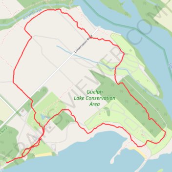
Guelph Lake Conservation Area Loop
- Distance: 6.3 Km
- Elevation gain: 65 m
- Maximum elevation: 372 m
- Elevation loss: 63 m
- Minimum elevation: 349 m
- Moving time: 1 h 22 m
- Moving speed: 4.6 Km/h
- Maximum speed: 5.8 Km/h
- Total time: 1 h 22 m
- Global speed: 4.6 Km/h
Interactive trail map
Thank you for supporting this site ❤️
Make a donation
Make a donation
Trail profile
- Distance: 6.3 Km
- Elevation gain: 65 m
- Maximum elevation: 372 m
- Elevation loss: 63 m
- Minimum elevation: 349 m
- Moving time: 1 h 22 m
- Moving speed: 4.6 Km/h
- Maximum speed: 5.8 Km/h
- Total time: 1 h 22 m
- Global speed: 4.6 Km/h
Thank you for supporting this site ❤️
Make a donation
Make a donation
About this trail
Name: Guelph Lake Conservation Area Loop trail, distance, elevation, map, profile, GPS track
Coordinates: 43.59911 -80.26074 43.61307 -80.24079
Thank you for supporting this site ❤️
Make a donation
Make a donation
Other hiking, mountain biking, running and outdoor activity trails
Click on a trail to view its statistics, map and profile.
Ontario country roads
Distance: 150.4 Km • Elevation gain: 1,137 m • Maximum elevation: 497 m