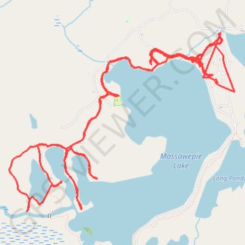
Massawepie Lake
- Distance: 21.7 Km
- Elevation gain: 275 m
- Maximum elevation: 482 m
- Elevation loss: 276 m
- Minimum elevation: 460 m
- Moving time: 5 h 25 m
- Moving speed: 4.0 Km/h
- Maximum speed: 25.3 Km/h
- Total time: 1 d 12 h
- Global speed: 0.6 Km/h
Interactive trail map
Trail profile
- Distance: 21.7 Km
- Elevation gain: 275 m
- Maximum elevation: 482 m
- Elevation loss: 276 m
- Minimum elevation: 460 m
- Moving time: 5 h 25 m
- Moving speed: 4.0 Km/h
- Maximum speed: 25.3 Km/h
- Total time: 1 d 12 h
- Global speed: 0.6 Km/h
About this trail
Name: Massawepie Lake trail, distance, elevation, map, profile, GPS track
Coordinates: 44.25033 -74.66810 44.26726 -74.63811
Other hiking, mountain biking, running and outdoor activity trails
Click on a trail to view its statistics, map and profile.