Import a GPX file

Hudson Highlands State Park - Canada Hill, White Rock, Sugarloaf Hill and Hudson River

#Hiking #Loop

  • Distance: 20.3 Km
  • Elevation gain: 506 m
  • Maximum elevation: 276 m
  • Elevation loss: 507 m
  • Minimum elevation: 2 m
  • Moving time: 4 h 4 m
  • Moving speed: 5.0 Km/h
  • Maximum speed: 10.2 Km/h
  • Total time: 4 h 20 m
  • Global speed: 4.7 Km/h

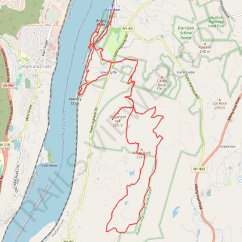
Interactive trail map

Trail profile

  • Distance: 20.3 Km
  • Elevation gain: 506 m
  • Maximum elevation: 276 m
  • Elevation loss: 507 m
  • Minimum elevation: 2 m
  • Moving time: 4 h 4 m
  • Moving speed: 5.0 Km/h
  • Maximum speed: 10.2 Km/h
  • Total time: 4 h 20 m
  • Global speed: 4.7 Km/h

About this trail

Name: Hudson Highlands State Park - Canada Hill, White Rock, Sugarloaf Hill and Hudson River trail, distance, elevation, map, profile, GPS track

Start: Sugarloaf Trail, Glenclyffe, Town of Philipstown, Putnam County, New York, 10524, United States (41.37035 -73.94489)

End: 25, Wing and Wing Road, Glenclyffe, Town of Philipstown, Putnam County, New York, 10524, United States (41.37014 -73.94526)

Coordinates: 41.33851 -73.95587 41.37976 -73.93501

Other hiking, mountain biking, running and outdoor activity trails

Click on a trail to view its statistics, map and profile.

Montréal - New York

Canada > Quebec > Urban agglomeration of Montreal > Montreal

#Bike #Montréal #NewYork

Distance: 637.6 Km • Elevation gain: 4,860 m • Maximum elevation: 301 m